↓
 

Savannah Land Surveying

Local Land Surveyors in Savannah, GA

Savannah Land Surveying
(912) 244-7767
Savannah Land Surveying
  • Home
  • ALTA Survey
    • Bowling Green, KY
    • Clarksville, GA
    • Jackson, MS
    • Jackson, GA
    • Lexington, KY
    • Louisville, KY
    • Memphis, GA
  • Boundary Surveying
  • Construction Survey
  • Drone LiDAR Mapping
  • Elevation Certificate
  • Land Surveying
  • Topographic Survey
  • About Us
  • Blog
  • Contact Us
Home 1 2 3 … 6 7 >>

Post navigation

← Older posts

Welcome to Savannah Land Surveying

Savannah Land Surveying Posted on August 18, 2017 by SavannahSurveyorApril 16, 2018

This site is intended to provide you with information on Land Surveying in the Savannah, GA and Chatham County area of Georgia. If you’re looking for a Savannah Land Surveyor, you’ve come to the right place. If you’d rather talk to someone about your land surveying needs, please call our local number at (912) 244-7767 today. For more information, please continue to read.

land surveyingLand Surveyors are professionals who make precise measurements to determine the size and boundaries of a piece of real estate.  While this is a simplistic definition, boundary surveying is one of the most common types of surveying related to home and land owners. If you fall into the following categories, please click on the appropriate link for more information on that subject:

Savannah Land Surveying services:

    1. I need to know where my property corners or property lines are. (Boundary Survey)
    2. I have a loan closing or re-finance coming up on my home in a subdivision. (Lot Survey)
    3. I need a map of my property with contour lines to show elevation differences for my architect or engineer. (Topo Survey)
    4. I’ve just been told I’m in a flood zone or I’ve been told I need an elevation certificate in order to obtain flood insurance or prove I don’t need it. (Flood Survey)
    5. I’m purchasing a lot/house in a recorded subdivision. (Lot Survey – See Boundary Survey if you’re not in a subdivision.)
    6. I’m purchasing a larger tract of land, acreage, that hasn’t been subdivided in the past. (Boundary Survey)

Contact Savannah Land Surveying services TODAY at (912) 244-7767.

Posted in boundary surveying, elevation certificate, land surveying, land surveyor | Tagged boundary survey, land surveyor, land surveyor savannah tn, Savannah Land Surveying

Elevation Certificates Are Becoming a Priority for Waterfront Property Owners

Savannah Land Surveying Posted on June 25, 2026 by SavannahSurveyorJune 24, 2026
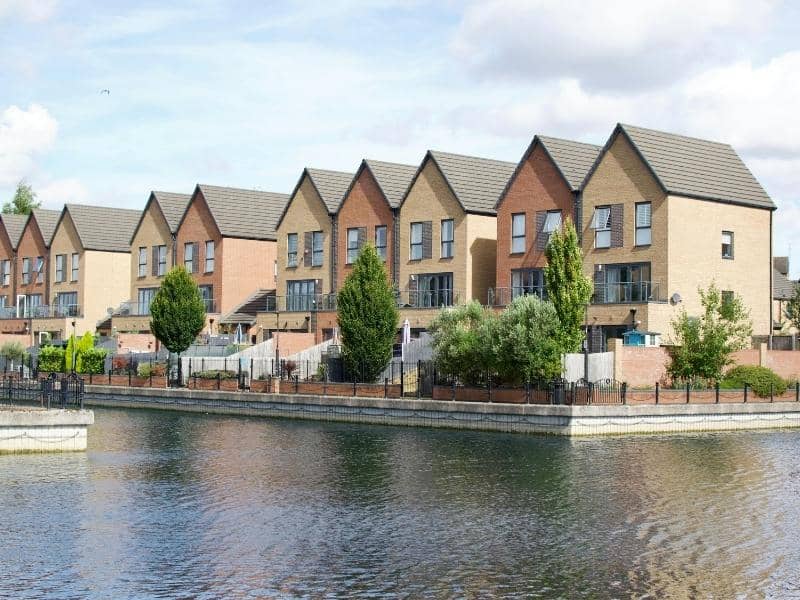
Waterfront residential properties where elevation certificates help support flood insurance, lending reviews, and compliance documentation.

Living near water brings beautiful views and easy access to lakes, rivers, or the sea. It also comes with a higher chance of flooding, and this risk changes how property is managed, insured, and financed. Over time, rules and risk assessments have grown more detailed. Elevation certificates have moved from being optional papers to essential documents for anyone who owns land or buildings along the water. These official records show exactly how high a structure sits compared to the expected flood level, and they help owners make smart choices while meeting important requirements.

Why Insurance Providers Are Requesting Elevation Certificates More Frequently

Insurance companies need clear facts to judge how much risk a property faces. They use these facts to decide if they will offer coverage and what rates to charge. In the past, general flood zone maps were often enough to make these decisions. Today, those maps are updated more often, and they do not always show the exact height of every single building.

Waterfront areas shift and change over time. Shorelines move, water levels rise and fall, and storm patterns become more intense. All of these factors change the level of risk for a home or business. An elevation certificate gives precise measurements taken directly on site. It tells insurers exactly where the lowest floor sits and how much higher it is than the base flood level.

Without this document, providers must rely on broad estimates, which usually lead to higher risk ratings or even limits on coverage. This is why more and more policy reviews and renewal requests now ask for a current certificate. It gives both sides a clear picture of what is at stake.

How Elevation Certificates Influence Flood Insurance Premium Calculations

The cost of flood insurance depends mostly on one simple comparison. How high is your building compared to the level water is expected to reach during a major storm? If your floors sit well above that level, the chance of damage is low, and rates stay more affordable. If they sit near or below that level, the risk goes up, and so does the cost.

An elevation certificate provides the exact numbers needed to make this comparison. It records the elevation of the ground, the lowest floor, and any key parts of the structure. These details replace guesswork with real data. When the numbers show a building is higher than assumed, owners often qualify for lower premium rates.

Even small differences in height can make a big difference in cost. A building that sits just a few centimeters above the base flood level may fall into a lower risk group. This can save hundreds or even thousands of dollars each year. The certificate acts as proof that supports these better rates.

Supporting Mortgage and Refinancing Requirements for Waterfront Properties

Lenders take a careful look at properties located near water. They need to protect their investment, and they want to know exactly what risks come with the land. When you apply for a new loan or ask to refinance an existing one, they will review all factors that could affect the property’s value and safety.

An elevation certificate is often part of this review process. It shows the true position of the building and confirms that it meets local rules for flood safety. This document proves that the structure is built to handle the conditions of its location.

Lenders use this information to decide on loan terms and to make sure proper insurance is in place. Having a current certificate ready speeds up the process and avoids delays caused by missing details. It gives both the borrower and the bank confidence that the property fits all necessary standards.

Using Elevation Certificates to Document Building Compliance

Most waterfront areas follow strict rules about how high new buildings must be constructed. These rules are set to reduce damage during floods and protect lives and property. When construction is finished or when changes are made to an existing building, owners must show that the work follows these rules.

An elevation certificate serves as the official record for this check. It lists the height of the lowest floor, the height of the adjacent ground, and the official flood level for the area. Surveyors prepare this document using accurate tools and official benchmarks.

Local planning offices and building departments accept this report as proof of compliance. If you ever want to add rooms, raise the structure, or make other changes, you will need this same information. Keeping a valid certificate on hand means you can show you meet requirements without having to arrange new measurements every time.

Why Current Elevation Records Can Strengthen Future Property Transactions

When it is time to sell a waterfront property, buyers and their agents look closely at flood risk and costs. Uncertainty about these points can slow down a sale or lower the price someone is willing to pay. Questions about insurance rates, loan approval, or safety can create doubt that is hard to clear up without solid proof.

An updated elevation certificate removes this uncertainty. It provides a clear, time-stamped record of the building’s position and risk level. Buyers can use it to estimate insurance costs and confirm that the property fits their budget. Lenders can review it quickly to approve financing.

Having this document ready also shows you have taken good care of the property and kept records up to date. It makes the transaction smoother and faster, and it protects both the seller and the buyer from surprises later on.

Frequently Asked Questions

What information is included in an elevation certificate?

It lists the location of the property, the elevation of the ground around it, the height of the lowest floor, and the official base flood level for the area. It also includes details about the surveyor, the date of measurement, and any relevant notes about the structure.

Why might an insurance company request an elevation certificate?

They use it to measure the true risk of flooding. The document gives exact height data that general maps cannot provide. This helps them set fair rates and decide what level of coverage fits the property.

Can an elevation certificate affect flood insurance costs?

Yes. If the measurements show the building sits higher than the mapped flood level, you may qualify for lower premiums. If it sits lower, you will understand the risk and cost clearly before buying coverage.

When do lenders typically require elevation certificates?

They ask for this document when approving new mortgages, refinancing existing loans, or reviewing properties located in or near flood zones. It helps them confirm the property meets safety and lending standards.

How often should waterfront property owners update elevation documentation?

A certificate remains valid as long as no major changes happen to the building or the surrounding land. However, it is wise to get a new survey if flood maps are updated, if the structure is raised or modified, or every five to ten years to match current conditions.

Posted in elevation certififate | Tagged elevation certificate

Why Your Lender Wants an ALTA Survey Before Closing

Savannah Land Surveying Posted on May 29, 2026 by SavannahSurveyorMay 27, 2026
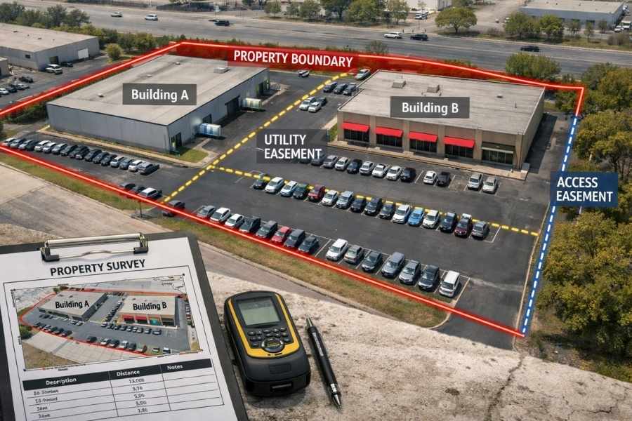
Commercial property showing ALTA survey boundary lines and easement locations before a real estate closing

If you are buying or financing a commercial property, there is a good chance your lender has already asked for an ALTA survey. It sounds like just another item on a long checklist, but it is actually one of the most important steps in any commercial real estate deal. 

So What Exactly Is an ALTA Survey?

An ALTA survey is a detailed land survey that follows a set of national standards created by the American Land Title Association (ALTA) and the National Society of Professional Surveyors (NSPS). It is the most thorough type of survey used in real estate, and most lenders and title insurance companies require one before a commercial property deal can close.

Unlike a standard boundary survey, which only shows property lines, an ALTA survey goes much further. It documents boundaries, buildings, easements, encroachments, access points, utilities, flood zone information, and more. The result is a complete, verified picture of the property that every party in the transaction can rely on.

The current standard is the 2026 ALTA/NSPS Minimum Standard Detail Requirements, which took effect on February 23, 2026. Any ALTA survey started on or after that date must follow these updated rules.

What Does an ALTA Survey Actually Cover?

Here is what every base ALTA survey includes:

  • Property boundaries. The exact legal lines of the property, confirmed on the ground.
  • Buildings and improvements. All structures on the property, including parking areas and paved surfaces.
  • Easements and rights-of-way. Any recorded access rights, utility corridors, or shared use agreements that affect the land.
  • Encroachments. Any structures or features that cross over a property line in either direction.
  • Access points. How the property connects to public roads and whether that access is legally confirmed.
  • Flood zone information. Whether the property falls within a FEMA-designated flood zone.
  • Utilities. The location of visible above-ground utility features serving the property.

On top of the base survey, lenders and title companies can request optional add-ons called Table A items. The 2026 ALTA/NSPS standards include 20 of these optional items, covering things like zoning classification, wetlands boundaries, building dimensions, underground utilities, and neighboring property owner information. Each item adds to the cost but also adds another layer of protection for everyone involved.

How Is It Different from a Regular Boundary Survey?

A lot of buyers assume a basic boundary survey will do the job. In most commercial transactions, it will not. Here is why.

FeatureBoundary SurveyALTA Survey
StandardsVaries by stateUniform national ALTA/NSPS standards
Who Accepts ItLocal authorities, neighborsLenders, title companies, attorneys
What It ShowsProperty lines onlyBoundaries, buildings, easements, utilities, encroachments, and more
Typical UseResidential, fencing, basic disputesCommercial purchases, refinancing, development
Typical Cost$500 to $2,500$3,000 to $8,000 and up

The key difference is consistency. An ALTA survey follows a national standard that every lender and title company in the country recognizes. A boundary survey done in Georgia may not satisfy a lender based in another state, but an ALTA survey always will.

Why Do Lenders and Title Companies Require It?

When a lender finances a commercial property, they are putting up a large sum of money secured by that land and its buildings. They need to know exactly what they are taking as collateral. Title insurance companies face the same challenge. Before issuing a policy, they need proof that the property is legally clean and physically what the documents say it is.

A title search reviews public records but cannot tell you what is physically happening on the ground. An ALTA survey fills that gap. It can uncover:

  • A neighboring building that has crept over the property line
  • An easement that would block a planned new structure
  • An access issue that limits how the property can be used
  • Flood zone designations that affect loan terms or insurance costs
  • Zoning violations that could cause legal problems after closing

Without an ALTA survey, these issues can stay hidden until after closing, when fixing them becomes far more expensive. With one, buyers and lenders can address problems before any money changes hands.

When Do You Need One?

You need an ALTA survey in any of these situations:

  • Purchasing a commercial property. Most lenders will not approve financing without one.
  • Refinancing a commercial property. The lender may require a new survey or a recertification of an existing one.
  • Leasing a large commercial space. Major commercial leases sometimes require ALTA surveys to confirm property details.
  • Developing or redeveloping a site. Before breaking ground, developers need to confirm boundaries, easements, and any restrictions on the land.
  • Resolving a title dispute. If a title insurance claim or boundary issue comes up, an ALTA survey provides the verified documentation needed to resolve it.

How Much Does It Cost?

An ALTA survey for a standard commercial property typically costs between $3,000 and $8,000. Complex properties or those with many Table A items requested can run $10,000 to $15,000 or more.

Here are the main factors that affect the price:

  • Property size and shape. Larger or irregularly shaped properties take more time to survey.
  • Number of Table A items requested. Each optional item adds research, fieldwork, or analysis time.
  • Availability of existing records. If prior surveys, deeds, and title documents are easy to access, the work goes faster and costs less.
  • Urgency. Rush surveys cost significantly more. Starting the process 6 to 8 weeks before your closing date avoids fees that can be substantial.
  • Location. Survey costs vary by region. Properties in the Savannah metro area tend to fall toward the middle of the national range.

How Long Does It Take?

A standard ALTA survey takes 2 to 3 weeks from start to finish deliverable. Properties that are more complex or have limited existing records may take 3 to 4 weeks. Rush turnaround of 5 to 7 business days is available from most firms, though it comes at an added cost.

The earlier you order the survey, the better. Lenders and title companies have their own review timelines, and ordering early keeps your closing date on track.

Frequently Asked Questions

Does an ALTA survey expire? 

There is no fixed expiration date, but lenders set their own rules. Fannie Mae requires the survey to be no older than 360 days before the recording date. Freddie Mac requires it within 90 days of the Note date. HUD and FHA require a new survey completed within 90 days. Always confirm the requirement with your lender early in the process.

Can I use an old ALTA survey for a new deal? 

Sometimes. If the property has not changed and the survey falls within the lender’s accepted timeframe, it may still be usable. A surveyor can also recertify an existing survey for a new transaction, which costs less than starting from scratch.

Do I need one even if my lender does not require it? 

Most lenders will require one, but even if yours does not, getting an ALTA survey is strongly recommended. It protects your investment by making sure there are no hidden problems with the property before you close.

Who pays for the ALTA survey? 

The buyer or borrower typically covers the cost as part of their due diligence expenses during the transaction.

Posted in alta survey | Tagged alta survey

What Is a Topographic Survey and Do You Actually Need One?

Savannah Land Surveying Posted on May 28, 2026 by SavannahSurveyorMay 27, 2026
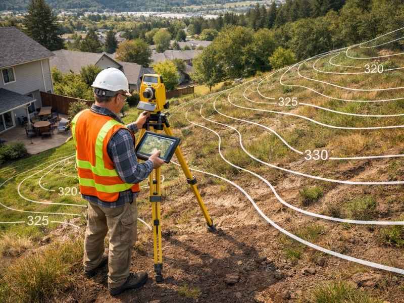
Land surveyor performing a topographic survey on a sloped residential property with contour elevation mapping

If you are getting ready to build a home or make big changes to your property, you have probably heard the words “topographic survey” come up. It sounds technical, but the idea behind it is pretty simple. This article explains what it is, what it includes, and whether you actually need one.

What Is a Topographic Survey?

A topographic survey is a detailed map of your land. It shows how the ground goes up and down, where water flows, and what is sitting on the property, whether that is trees, buildings, or drainage features.

Think of it this way. A regular map shows you where things are. A topographic survey shows you what the land is actually shaped like. That difference matters a lot when you are planning a construction project.

This type of survey is used by builders, architects, engineers, and developers. Before anyone starts designing a structure or moving dirt, they need to understand the land they are working with.

What Does a Topographic Survey Include?

When a licensed surveyor comes to your property, here is what they will measure and record:

  • Contour lines. These lines on the map connect spots that are at the same height. They show where the land slopes up or down.
  • Spot elevations. These are exact height measurements taken at specific points like driveways, doorways, and low-lying areas.
  • Natural features. Trees, streams, ponds, and wetlands are all recorded on the map.
  • Man-made structures. Things like buildings, fences, roads, utility poles, and manholes are included too.
  • Drainage patterns. The survey shows where water naturally flows across the land and where it tends to collect.

Everything is drawn to scale. Most residential surveys use contour lines spaced 1 to 2 feet apart. Projects that need extra detail may use spacing as tight as half a foot.

How Is It Different from a Boundary Survey?

A lot of people mix these two up, so it is worth a quick explanation.

A boundary survey tells you where your property lines are. A topographic survey tells you what the land inside those lines looks like. They answer two completely different questions, and many building projects actually require both.

FeatureBoundary SurveyTopographic Survey
PurposeFinds your legal property linesMaps the shape and features of the land
Who Uses ItProperty owners, attorneys, title companiesBuilders, architects, engineers
What You GetA map showing property corners and linesA contour map with elevations and site features
When You Need ItBuying land, building a fence, legal disputesConstruction, drainage design, permit applications

When Do You Actually Need One?

Here is a simple rule. If your project involves moving dirt, building something new, or dealing with water drainage, you probably need a topographic survey.

Some of the most common situations include:

  • Building a new home. Builders and engineers need to know the lay of the land before placing a foundation.
  • Adding a deck, room, or large outdoor structure. Even smaller projects can affect how water drains around your home.
  • Developing or splitting land. Developers use topographic surveys to check if a site is suitable before buying it.
  • Fixing a drainage or flooding problem. The survey shows exactly where water is going and why it is causing issues.
  • Applying for a building or grading permit. In Savannah and Chatham County, local authorities often require a topographic survey before they will approve certain permits.
  • Installing a retaining wall, road, or utility line. Any project that involves cutting into or filling up the ground needs solid elevation data first.
  • Environmental or wetlands review. Agencies need to see the existing terrain before approving land use changes near sensitive areas.

What Happens If You Skip It?

Some people skip the topographic survey to save money upfront. That decision usually ends up costing more in the long run.

Here is what can go wrong:

  • A foundation gets placed in an area that is prone to flooding or has weak soil
  • Water starts pooling against the side of a building and causes damage over time
  • A drainage system is built in the wrong direction because no one checked the slope
  • A permit application gets rejected because the required elevation data is missing
  • Construction has to stop mid-project because of terrain issues nobody expected

Getting a topographic survey done before work starts helps you avoid all of these problems. It gives your whole team a clear picture of the land so there are no surprises.

How Much Does It Cost?

Across the country, a topographic survey for a standard residential lot usually runs between $400 and $1,500. In Georgia and nearby Florida markets, most lots under one acre fall somewhere between $1,200 and $3,500.

Here is what affects the price:

  • Size of the property. Bigger lots take more time and effort to survey.
  • How complex the terrain is. A wooded or hilly lot takes longer than a flat, open one.
  • How detailed the map needs to be. Tighter contour intervals cost more but give you more precise data.
  • The method used. Drone surveys using LiDAR technology can cost 30 to 50 percent less than traditional ground surveys on larger properties.
  • The type of final map. A basic 2D contour map costs less than a full 3D terrain model.

How Does the Surveyor Do It?

A licensed surveyor uses a mix of tools to collect data in the field. GPS equipment picks up precise location and elevation readings from satellites. A total station measures angles and distances across the ground. On larger or harder-to-reach properties, drones with cameras and LiDAR sensors can fly over the site and capture detailed aerial data.

After the fieldwork is done, all of that information gets processed using CAD software. The result is a scaled, accurate topographic map that becomes the starting point for your entire project.

Frequently Asked Questions

Is a topographic survey the same as a regular land survey? 

Not quite. A land survey is a general term that covers several different types of surveys. A topographic survey is one specific kind that focuses on elevation and terrain. Others include boundary surveys, ALTA surveys, and construction surveys.

How long does the whole thing take? 

The fieldwork on a standard residential lot is usually done in a single day. Getting the finished map back typically takes 3 to 7 business days after that.

Does Savannah require one before issuing permits? 

It depends on the project, but yes, the City of Savannah and Chatham County often require topographic data for grading permits, stormwater plans, and site development applications. A licensed local surveyor can tell you exactly what your project needs.

Posted in land surveying | Tagged topographic survey

Post navigation

← Older posts
Get Quote Button
© Boxer Survey USA
Savannah Land Surveying

Savannah, Georgia
Phone: (912) 244-7767

Privacy Policy | Terms of Use

Web Development and SEO by:
AuburnBusiness.com, LLC

The owner of this website, Boxer Survey USA, provides coordination of professional land surveying and engineering services in all 50 states. The professional surveying and engineering services provided to you will be conducted by fully licensed professionals in your state.

↑