
What Is a Topographic Survey and Do You Actually Need One?
If you are getting ready to build a home or make big changes to your property, you have probably heard the words “topographic survey” come up. It sounds technical, but the idea behind it is pretty simple. This article explains what it is, what it includes, and whether you actually need one.
What Is a Topographic Survey?
A topographic survey is a detailed map of your land. It shows how the ground goes up and down, where water flows, and what is sitting on the property, whether that is trees, buildings, or drainage features.
Think of it this way. A regular map shows you where things are. A topographic survey shows you what the land is actually shaped like. That difference matters a lot when you are planning a construction project.
This type of survey is used by builders, architects, engineers, and developers. Before anyone starts designing a structure or moving dirt, they need to understand the land they are working with.
What Does a Topographic Survey Include?
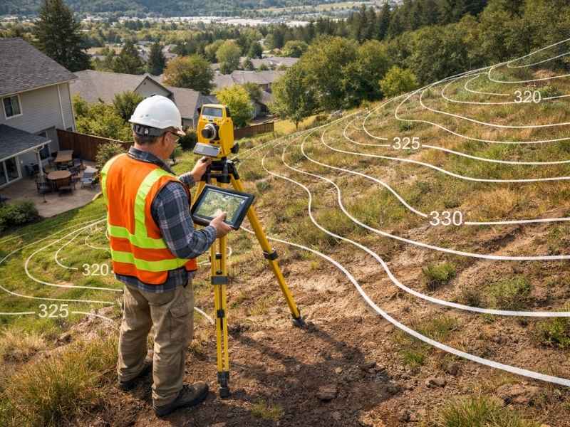
When a licensed surveyor comes to your property, here is what they will measure and record:
- Contour lines. These lines on the map connect spots that are at the same height. They show where the land slopes up or down.
- Spot elevations. These are exact height measurements taken at specific points like driveways, doorways, and low-lying areas.
- Natural features. Trees, streams, ponds, and wetlands are all recorded on the map.
- Man-made structures. Things like buildings, fences, roads, utility poles, and manholes are included too.
- Drainage patterns. The survey shows where water naturally flows across the land and where it tends to collect.
Everything is drawn to scale. Most residential surveys use contour lines spaced 1 to 2 feet apart. Projects that need extra detail may use spacing as tight as half a foot.
How Is It Different from a Boundary Survey?
A lot of people mix these two up, so it is worth a quick explanation.
A boundary survey tells you where your property lines are. A topographic survey tells you what the land inside those lines looks like. They answer two completely different questions, and many building projects actually require both.
| Feature | Boundary Survey | Topographic Survey |
| Purpose | Finds your legal property lines | Maps the shape and features of the land |
| Who Uses It | Property owners, attorneys, title companies | Builders, architects, engineers |
| What You Get | A map showing property corners and lines | A contour map with elevations and site features |
| When You Need It | Buying land, building a fence, legal disputes | Construction, drainage design, permit applications |
When Do You Actually Need One?
Here is a simple rule. If your project involves moving dirt, building something new, or dealing with water drainage, you probably need a topographic survey.
Some of the most common situations include:
- Building a new home. Builders and engineers need to know the lay of the land before placing a foundation.
- Adding a deck, room, or large outdoor structure. Even smaller projects can affect how water drains around your home.
- Developing or splitting land. Developers use topographic surveys to check if a site is suitable before buying it.
- Fixing a drainage or flooding problem. The survey shows exactly where water is going and why it is causing issues.
- Applying for a building or grading permit. In Savannah and Chatham County, local authorities often require a topographic survey before they will approve certain permits.
- Installing a retaining wall, road, or utility line. Any project that involves cutting into or filling up the ground needs solid elevation data first.
- Environmental or wetlands review. Agencies need to see the existing terrain before approving land use changes near sensitive areas.
What Happens If You Skip It?
Some people skip the topographic survey to save money upfront. That decision usually ends up costing more in the long run.
Here is what can go wrong:
- A foundation gets placed in an area that is prone to flooding or has weak soil
- Water starts pooling against the side of a building and causes damage over time
- A drainage system is built in the wrong direction because no one checked the slope
- A permit application gets rejected because the required elevation data is missing
- Construction has to stop mid-project because of terrain issues nobody expected
Getting a topographic survey done before work starts helps you avoid all of these problems. It gives your whole team a clear picture of the land so there are no surprises.
How Much Does It Cost?
Across the country, a topographic survey for a standard residential lot usually runs between $400 and $1,500. In Georgia and nearby Florida markets, most lots under one acre fall somewhere between $1,200 and $3,500.
Here is what affects the price:
- Size of the property. Bigger lots take more time and effort to survey.
- How complex the terrain is. A wooded or hilly lot takes longer than a flat, open one.
- How detailed the map needs to be. Tighter contour intervals cost more but give you more precise data.
- The method used. Drone surveys using LiDAR technology can cost 30 to 50 percent less than traditional ground surveys on larger properties.
- The type of final map. A basic 2D contour map costs less than a full 3D terrain model.
How Does the Surveyor Do It?
A licensed surveyor uses a mix of tools to collect data in the field. GPS equipment picks up precise location and elevation readings from satellites. A total station measures angles and distances across the ground. On larger or harder-to-reach properties, drones with cameras and LiDAR sensors can fly over the site and capture detailed aerial data.
After the fieldwork is done, all of that information gets processed using CAD software. The result is a scaled, accurate topographic map that becomes the starting point for your entire project.
Frequently Asked Questions
Is a topographic survey the same as a regular land survey?
Not quite. A land survey is a general term that covers several different types of surveys. A topographic survey is one specific kind that focuses on elevation and terrain. Others include boundary surveys, ALTA surveys, and construction surveys.
How long does the whole thing take?
The fieldwork on a standard residential lot is usually done in a single day. Getting the finished map back typically takes 3 to 7 business days after that.
Does Savannah require one before issuing permits?
It depends on the project, but yes, the City of Savannah and Chatham County often require topographic data for grading permits, stormwater plans, and site development applications. A licensed local surveyor can tell you exactly what your project needs.